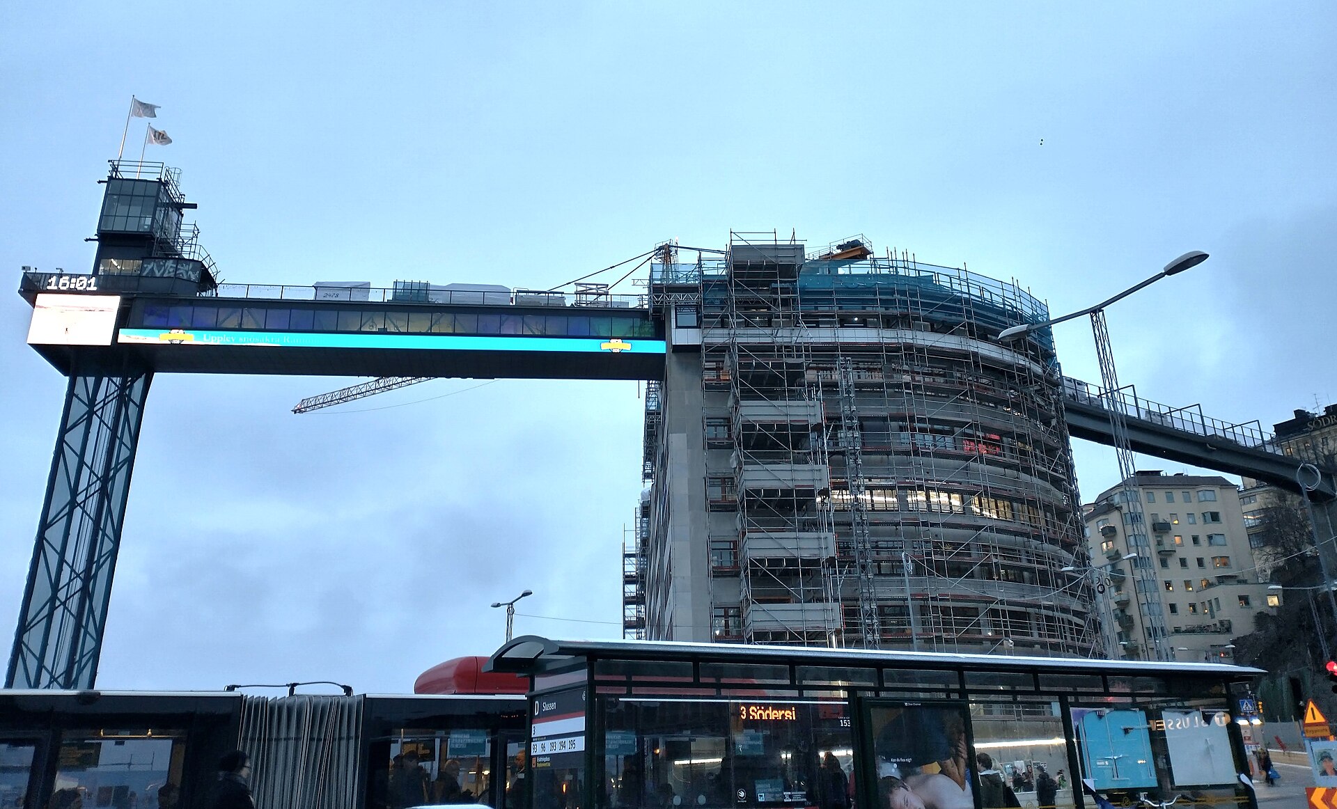
Katarinahissen is a public lift and viewing platform on Södermalm that carries pedestrians up the steep rock face between Slussen, at water level, and Mosebacke torg, roughly 38 metres above. The current steel structure dates from 1935, replacing a wooden lift from 1883 — one of Stockholm’s oldest pieces of surviving public transport infrastructure.
Where is Katarinahissen, and what does it connect?
Katarinahissen stands at the edge of Slussen, the lock and traffic junction where Lake Mälaren meets the Baltic inlet of Saltsjön. It links the low ground around Södermalmstorg to Mosebacke torg, a small square at the top of Katarinaberget on Södermalm, the island directly south of Gamla Stan.
The two ends of the lift sit at very different heights. At the bottom, it opens onto the busy junction of Slussen itself, which has been undergoing a long, well-documented rebuild described in detail in what Slussen is and why it has been rebuilt. At the top, it opens onto the quieter streets around Mosebacke, close to the cliffside route of Fjällgatan, Stockholm’s cliffside view street.
How old is Katarinahissen, and why was it rebuilt?
The first Katarinahissen opened in 1883 as one of Sweden’s earliest public lifts, a wooden tower built to spare pedestrians the long climb between the harbour and the heights of Södermalm. It was rebuilt in steel and reopened in 1935 as part of a wider redevelopment of the Slussen area, giving the structure its current, more angular profile.
Stockholm’s City Museum, Stadsmuseet, lists buildings and structures of high heritage value using a colour-coded classification system, and Katarinahissen is among the structures the museum treats as historically significant to the city’s built environment — a status attributed to the museum’s own records rather than to any marketing claim.

What is the view like from the top of Katarinahissen?
The platform sits high enough to look out over Riddarfjärden and the channel where Mälaren empties toward the Baltic, with Gamla Stan’s rooftops and spires visible to the north and the wooded shoreline of Djurgården beyond. It offers one of central Stockholm’s widest unobstructed sightlines from a built structure, rather than from open ground.
That puts it in the same broad category as two other elevated points on Södermalm’s northern edge: Fjällgatan, and the walking route along Monteliusvägen, Stockholm’s cliffside viewpoint. All three look north across the same water and skyline, but from different heights and different kinds of access — two are open streets, while Katarinahissen is a constructed tower with a lift mechanism and, historically, a ticketed platform.
Is Katarinahissen open to the public right now?
Access has been intermittent in recent years. The lift and its upper walkway have been closed for extended periods for structural renovation work tied to the surrounding Slussen rebuild, and reopening has been announced and delayed more than once. Because operating status changes, readers should confirm current access directly with the City of Stockholm’s Slussen project pages before planning around it, rather than relying on any fixed claim here.
This pattern of closure is itself part of a durable story about the site: Katarinahissen has spent much of its working life either under repair or awaiting it, which is consistent with its age and its exposed, load-bearing steel structure directly above an active traffic and lock complex.
What is Gondolen, and how does it relate to Katarinahissen?
Gondolen is a long-established restaurant built onto the Katarinahissen tower, opened alongside the 1935 rebuild and suspended in a gondola-shaped section below the main walkway. It occupies part of the same steel structure and shares its elevated position over Slussen, though it operates on its own schedule and is a separate commercial business rather than part of the lift’s public access.
The pairing of a functional lift with an attached restaurant reflects how the 1935 rebuild treated the site: not purely as transport infrastructure, but as a piece of civic architecture meant to be occupied and looked out from, in the same spirit as several of the city’s other elevated public spaces.
How does Katarinahissen fit into the Slussen rebuild?
Katarinahissen sits directly above the Slussen lock and junction complex, which the City of Stockholm has been reconstructing over an extended multi-year project covering the lock gates, roads, bus terminal and public squares. Because the lift’s base and surrounding ground level are part of that same construction zone, its access, opening hours and even physical approach have shifted repeatedly as the wider project has progressed.
Anyone planning a visit around Katarinahissen should treat it as one element within an active building site rather than a fixed, static landmark — the fuller account of what is being rebuilt at Slussen and why explains the surrounding disruption in more detail.
How do you get to Katarinahissen?
The nearest public transport hub is Slussen itself, served by Stockholm’s metro red and green lines as well as multiple bus routes, all converging at the base of the lift. From street level at Södermalmstorg, the tower is visible immediately above the water; from the top, entry is via Mosebacke torg on Södermalm.
- By metro or bus: alight at Slussen station and follow signage toward Södermalmstorg.
- By foot from Gamla Stan: cross via the Slussen bridges, a short walk across the lock complex.
- By foot from Södermalm: approach from Mosebacke torg at the upper end, near Fjällgatan.
General guidance on how Stockholm’s transport card, zones and lines work is covered in the site’s Getting Around section. For context on the wider district Katarinahissen sits within, see the Neighbourhoods archive, and for other elevated or historic structures around the city, the Landmarks & Sights archive covers comparable sites.
Access Stockholm is an independent guide written from published, checkable sources. We have not visited the places described here and we do not publish personal recommendations or invented ‘local favourites’ — where something is singled out as notable, we say who says so. Opening times, fares, closures and prices change at short notice, so treat everything here as a starting point and confirm with the museum, operator or venue directly before building a day around it. We give no advice on visas, insurance, health or safety; use your own government’s official guidance for those.
Featured image: Photo by Holger.Ellgaard, source, CC BY-SA 3.0
