Slussen is the point in central Stockholm where Lake Mälaren meets the Baltic inlet Saltsjön, and where a system of locks manages the difference in water level between them. It sits between Gamla Stan and Södermalm, doubling as one of the city’s busiest transport interchanges. It has been rebuilt because the mid-20th-century structure holding all of this together was, by the 2000s, structurally failing.
What is Slussen, exactly?
Slussen is not one thing but three layered on top of each other: a lock system regulating water between fresh and salt water, a road and pedestrian junction, and a public transport hub. The name itself gives away the oldest function — sluss is Swedish for “lock” or “sluice”.
Geographically, Slussen occupies the narrow strip of land and water at the southern edge of Gamla Stan, Stockholm’s old town, where the island meets Södermalm across the channel known as Söderström. Everything moving between the two — road traffic, buses, pedestrians, cyclists, and boats — has historically had to pass through this single pinch point.
Why does Stockholm need a lock here at all?
Lake Mälaren sits at a different water level to the Baltic Sea, and the two bodies of water have different salinity. Slussen is the mechanism that keeps them apart while still allowing boats and, critically, excess water to pass between them.
Mälaren is not just a lake; it is the source of drinking water for well over a million people in the greater Stockholm region, and it is fed by a large catchment area upstream. Without a functioning lock and outflow system at Slussen, heavy rainfall or spring meltwater could raise the lake’s level faster than it can be released to the sea, with knock-on effects for flood risk around the lake’s shoreline settlements. The lock at Slussen is therefore not a historical curiosity kept for its own sake — it is active flood-control infrastructure for the whole Mälaren basin, a role the City of Stockholm’s own planning documents for the site treat as the primary engineering justification for rebuilding it at all.
A lock has stood at this site in some form since the 17th century, with the first version built in the 1640s under Queen Kristina. It has been rebuilt and re-engineered repeatedly since, each time to handle more water, more traffic, or both.
What was the old Slussen, and why did it fail?
The Slussen most associated with the name today — a distinctive multi-level “clover-leaf” road interchange stacked above the lock — was designed by the architect and engineer Tage William-Olsson and completed in 1935. It was, for its time, an ambitious solution to routing cars, trams and buses over and around a working lock without one blocking the other.
By the early 2000s, the concrete of that structure was decaying badly. Structural inspections found parts of it in poor condition, and sections were closed to heavier traffic as a precaution. Rather than patch a 1930s structure indefinitely, the City of Stockholm opted for a full rebuild rather than a repair — a decision made public through the city’s own planning and construction announcements for the site over the following decade.
What does the rebuilt Slussen actually involve?
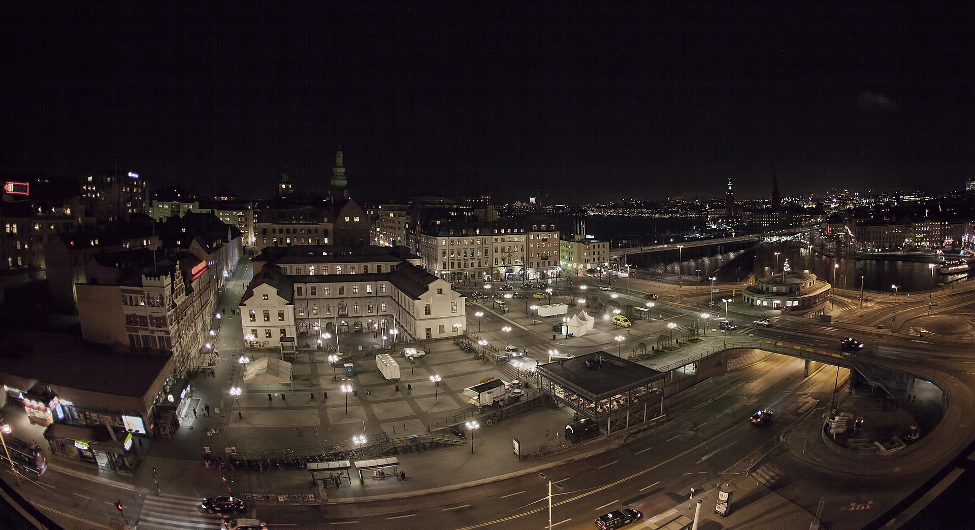
Construction on what the city refers to as “Nya Slussen” (New Slussen) began in the mid-2010s and has proceeded in stages, since the site cannot simply be closed — the lock, the roads and the transit interchange all had to keep functioning throughout. The project, as described on the City of Stockholm’s own planning pages, covers several distinct pieces of work:
- A new, higher-capacity lock and set of sluice gates, designed to move more water between Mälaren and the Baltic than the old system could manage.
- A rebuilt bus terminal, since Slussen remains a major interchange point for buses feeding into Södermalm and southern Stockholm.
- New pedestrian and cycling routes at quay level, replacing a layout that had prioritised car traffic since the 1930s.
- A reshaped public square, Slussplan, intended to function as usable open space rather than purely a traffic junction.
Completion dates for large infrastructure projects of this kind move; the city has revised its own timeline for full completion more than once since work began. Readers wanting the current state of construction and expected finish dates should check the City of Stockholm’s own project pages rather than rely on a fixed date here.
.jpg)
How does Slussen work as a transport hub?
Slussen is served by an interchange metro station on two of Stockholm’s three underground lines, plus a substantial bus terminal and connections for pedestrians and cyclists crossing between Gamla Stan, Södermalm and the wider inner city. For anyone travelling through central Stockholm by public transport, Slussen is frequently a station passed through rather than a destination in itself — one of a handful of interchange points, alongside T-Centralen, where lines and surface routes genuinely converge.
Because the site has been an active construction zone for years, pedestrian routes, bus stop locations and station entrances at Slussen have changed repeatedly during the rebuild. Both residents and visitors relying on the station should check current routing on the operator’s own site rather than assume a layout is fixed — SL, which runs Stockholm’s public transport network, publishes live service information and disruption notices for the station.
Why does the rebuild matter beyond Slussen itself?
The lock’s flood-control function connects Slussen to something much larger than one interchange. Rising water levels in Mälaren, driven by heavier rainfall patterns, put pressure on the lake’s shoreline communities and on the drinking-water supply drawn from it. A lock system with greater discharge capacity is the city’s stated engineering answer to that pressure, which is part of why the rebuild was treated as infrastructure rather than as a cosmetic redevelopment.
There is also a comparison worth making with another major square that Stockholm reshaped for very different reasons: Sergels Torg, built as a deliberately modern, sunken plaza in the 1960s as part of a wholesale rebuilding of the city’s commercial core. Slussen’s rebuild is the opposite kind of project — not a new statement of design, but the replacement of failing infrastructure that happens to sit underneath a public square people also use every day.
What is around Slussen for someone visiting the area?
Slussen sits at the boundary of two very different parts of central Stockholm. To the north is Gamla Stan, the medieval old town, and the small island of Riddarholmen just beyond it. To the south is Södermalm, a former working-class island now dense with housing, shops and cultural venues, including Fotografiska, the photography museum housed in a converted early-20th-century customs building close to the water.
Given the years of construction work, the immediate area around Slussen has looked more like a building site than a finished piece of city for much of the 2010s and 2020s, and that is worth setting expectations around rather than glossing over. Anyone planning to walk between Gamla Stan and Södermalm, or to change transport at Slussen station, should expect signposted diversions rather than a settled, finished streetscape until the city itself declares the project complete.
For context on how this fits into Stockholm’s wider pattern of landmarks and public squares, see the Landmarks & Sights archive, and for how Gamla Stan, Södermalm and the city’s other historic districts are organised, see the Neighbourhoods archive.
Access Stockholm is an independent guide written from published, checkable sources. We have not visited the places described here and we do not publish personal recommendations or invented ‘local favourites’ — where something is singled out as notable, we say who says so. Opening times, fares, closures and prices change at short notice, so treat everything here as a starting point and confirm with the museum, operator or venue directly before building a day around it. We give no advice on visas, insurance, health or safety; use your own government’s official guidance for those.
Featured image: Photo by Bengt Nyman, source, CC BY 3.0
.jpg)