Sergels Torg is the square at the centre of modern Stockholm, in the Norrmalm district: a sunken, triangle-paved pedestrian plaza set below a traffic roundabout, marked by a tall glass obelisk. It looks the way it does because it was built from scratch in the 1960s and 70s, after the city demolished the older district that stood there.
What exactly is Sergels Torg?
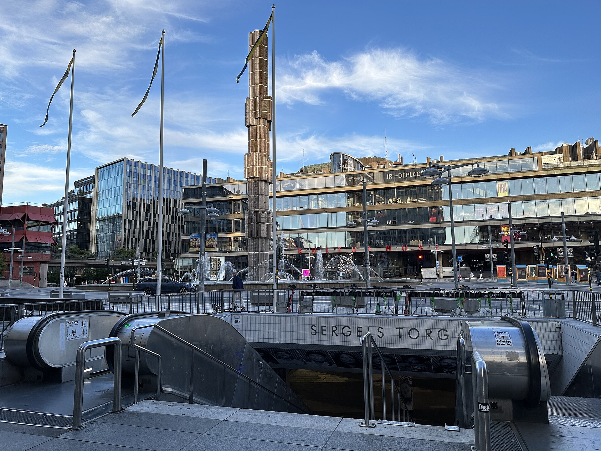
Sergels Torg is a public square where five of central Stockholm’s busiest streets meet — among them Sveavägen, Hamngatan and Klarabergsgatan. It sits on two levels. Above is a road roundabout carrying traffic around the square. Below, reached by stairs and escalators, is a car-free plaza known locally as Plattan (“the slab”), paved in a black-and-white triangular pattern that has become one of the most photographed patterns of ground surface in the city.
The square is named after Johan Tobias Sergel, the 18th-century Swedish sculptor, though it was not laid out until nearly two centuries after his death. It sits inside the wider Norrmalm district, immediately next to Stockholm’s other central neighbourhoods, and functions as one of the main pedestrian and transit junctions of the entire city.
Why does the square have two levels?
The split-level design was a deliberate piece of 1960s traffic planning: keep vehicles moving on a roundabout above, and give pedestrians a dedicated, car-free space below, connected directly into the underground network of walkways that link to Stockholm’s central metro hub. The lower plaza also opens onto underground shopping passages and forms part of the pedestrian route into T-Centralen, the interchange station for the Stockholm metro.
This kind of vertical separation of people and traffic was a fashionable planning idea across Europe in the postwar decades, and Stockholm applied it more thoroughly at Sergels Torg than almost anywhere else in the city.
What is the glass structure in the middle of the roundabout?
The sculpture rising from the centre of the roundabout is a glass obelisk titled Kristallvertikalaccent (“crystal vertical accent”), designed by the Swedish artist Edvin Öhrström and installed in the early 1970s. It is built from stacked glass prisms and is lit internally, so it functions as both a daytime sculpture and a night-time beacon visible along Sveavägen.
It has no ceremonial or religious function — it is a piece of public art commissioned specifically to mark the centre of the new square, and it has become the de facto symbol of Sergels Torg on maps, in news photography and in the city’s own imagery of itself.

Why was the old district here torn down?
Sergels Torg exists because Stockholm carried out one of postwar Europe’s most extensive inner-city demolition projects, known as the Norrmalmsregleringen (the Norrmalm redevelopment). Between roughly the 1950s and the 1970s, the city cleared large parts of the older Klara district — dense blocks of 19th-century apartment buildings, workshops and shops — to build a modern commercial and administrative centre.
The plan replaced that older fabric with a cluster of tall office and department-store towers on Hötorget known as the Hötorgsskraporna, new road infrastructure, and the sunken square that became Sergels Torg. The scale of demolition remains a point of public and academic debate in Sweden; city histories and planning archives document it as a decisive break with the older, low-rise Stockholm that had stood on the site for generations, and it is frequently cited alongside the redevelopment of Stortorget’s much older square in Gamla Stan as the clearest contrast in the city between preserved and rebuilt central Stockholm.
Architect David Helldén was the lead planner most closely associated with the square’s final layout, working within a series of city plans for the area that had been under discussion since the 1940s.
What is the building that overlooks the square?
The building most closely associated with Sergels Torg is Kulturhuset Stadsteatern, the glass-fronted cultural centre and city theatre designed by architect Peter Celsing and opened in stages through the 1970s. It houses exhibition spaces, a library, theatre stages and public reading rooms, and its long glazed façade forms one entire side of the square.
Kulturhuset is a public cultural institution rather than a single museum, and its programme changes regularly; details of current exhibitions and events are published on its own site rather than fixed here. For collections and institutions nearby with a narrower, fixed remit, the Hallwyl Museum on Hamngatan is a short walk from the square and preserves a 19th-century private palace largely as it was left to the state.
How does Sergels Torg work as a transport hub?
Sergels Torg sits directly above T-Centralen, the interchange station where all three Stockholm metro lines meet, and it is surrounded by major bus routes along Sveavägen, Hamngatan and Klarabergsgatan. The underground passages beneath the plaza connect directly into the station concourse, so for many residents the square functions less as a destination and more as a corridor between transport, shopping and the rest of central Stockholm.
Because of this, the square is busiest during weekday commuting hours and on Saturdays, when the surrounding shopping streets are at their fullest. Details of specific metro lines, fares and the SL travel card system are set by Stockholm’s transport operator and should be confirmed on its own site rather than assumed from older figures.
What happens at Sergels Torg besides passing through it?
The plaza’s size and central position make it Stockholm’s default site for public gatherings that need open, flat space in the city centre: political demonstrations, rallies, occasional markets and outdoor cultural events recur here through the year. It has also served, at various points, as a gathering point on New Year’s Eve, given its proximity to Kungsträdgården and the routes crowds take through the centre.
None of this follows a fixed annual calendar that can be listed reliably here — organisers and the city change locations and permissions from year to year — so any specific event at Sergels Torg is worth checking against current city or organiser announcements rather than assumed from past patterns.
How does Sergels Torg compare with Stockholm’s older squares?
Sergels Torg reads as deliberately different from the rest of central Stockholm precisely because it was built to be different: flat, modernist, laid out for cars and later carved back for pedestrians, in a district that otherwise still carries a great deal of pre-industrial and 19th-century structure. Visitors moving between it and Gamla Stan, Stockholm’s medieval old town, or the civic architecture around Stockholm City Hall, are moving between two entirely different eras of how the city chose to build itself.
That contrast is one reason planning historians treat Sergels Torg as a case study: it shows, in one square, what a mid-century European city planning department believed a modern civic centre should look like, built at the direct expense of what had stood there before.
Is Sergels Torg worth understanding rather than just passing through?
For a resident, Sergels Torg is mostly infrastructure — a transit interchange and a route through the city centre, not a destination in itself. For a visitor trying to understand how central Stockholm actually works, it is one of the clearest physical records of a specific decision the city made about its own history, and it sits within easy reach of several of the landmarks and historic sites that the same redevelopment left standing nearby, as well as institutions covered in the wider museums and galleries of central Stockholm.
Access Stockholm is an independent guide written from published, checkable sources. We have not visited the places described here and we do not publish personal recommendations or invented ‘local favourites’ — where something is singled out as notable, we say who says so. Opening times, fares, closures and prices change at short notice, so treat everything here as a starting point and confirm with the museum, operator or venue directly before building a day around it. We give no advice on visas, insurance, health or safety; use your own government’s official guidance for those.
Featured image: Photo by AleWi, source, CC BY-SA 4.0
