Monteliusvägen is a pedestrian path that runs along a rock ridge on the north side of Södermalm, Stockholm’s southern island district. It follows the edge of a cliff called Mariaberget, roughly 500 metres long, with an open view north across the water of Riddarfjärden toward Kungsholmen, Riddarholmen and Stockholm City Hall.
Where exactly is Monteliusvägen?
Monteliusvägen sits above Söder Mälarstrand, the waterfront road that runs along the northern shore of Södermalm. The path itself has no car traffic. It connects, at its western end, to a stairway down toward the water near Bastugatan, and at its eastern end to Ivar Los Park close to Slussen, the transport interchange and locks that separate Södermalm from Gamla Stan.
Anyone researching how that interchange fits together, and why it has been under long-term reconstruction, can find the background in this site’s article on what Slussen is and why it has been rebuilt.
Who was Monteliusvägen named after?
The path is named after Oscar Montelius (1843–1921), a Swedish archaeologist known for developing the “typological method” used to date prehistoric artefacts by their form and style, work that shaped how Scandinavian archaeology organised its chronology. He served as a professor and, later in his career, as an antiquarian at Sweden’s national antiquities board.
Stockholm’s streets and paths carry names assigned through the city’s formal naming process, recorded and kept by the city’s own archives, and Monteliusvägen is one of many public ways on Södermalm named after scholars and historical figures rather than after a feature of the landscape itself.
What can be seen from Monteliusvägen?
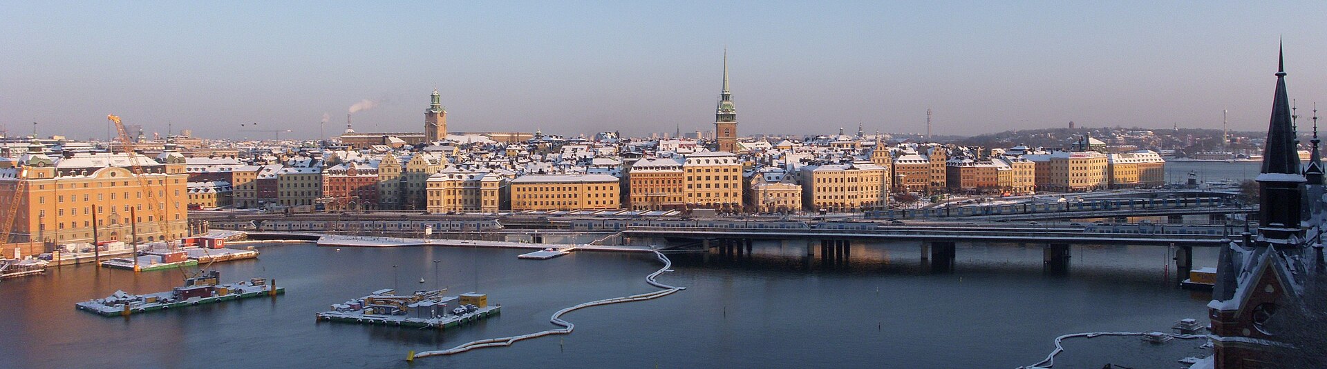
The path is valued chiefly as a viewpoint. Standing along the railing gives an unobstructed sightline across Riddarfjärden, the bay that separates Södermalm from Kungsholmen and the older core of the city, toward several structures covered elsewhere on this site:
- Stockholm City Hall, the red-brick building with the tower topped by three crowns, on the Kungsholmen shoreline.
- Riddarholmen, the small island with the church used as a royal burial site, visible to the east.
- Gamla Stan, Stockholm’s medieval old town, its rooftops and the Royal Palace forming part of the same skyline.
Because the path faces roughly north-west, the low sun in the hours before sunset falls directly along it for much of the year, which is why photographs of the view are common in guides to the city; Visit Stockholm, the city’s official tourism organisation, lists Monteliusvägen among its recommended vantage points over the water. That is an attributed claim about how the path is promoted, not a description of what it is like to stand there.

What is Mariaberget, and how does it connect to the path?
Mariaberget is the name of the ridge and the surrounding neighbourhood that Monteliusvägen runs along. It is one of the higher points on Södermalm, built up from the seventeenth century onward with wooden houses and narrow lanes climbing the rock face, some of which survive as protected buildings under Sweden’s heritage listing rules administered through the county administrative board.
The district sits within Södermalm generally, an island known for its steep topography, converted industrial buildings and dense residential streets. General background on how Stockholm’s districts are organised and what distinguishes them from one another is covered in this site’s Neighbourhoods archive.
How do you get to Monteliusvägen?
The path is reached on foot. The nearest metro stations are Slussen and Mariatorget, both served by Stockholm’s tunnelbana network; from either, the walk involves a climb up one of several stairways cut into the rock, since the path sits well above the level of the water and the roads below it.
There is no dedicated bus stop directly on Monteliusvägen itself, and no vehicle access — it functions purely as a pedestrian route. Readers working out how Stockholm’s public transport zones, cards and interchanges fit together more broadly can start with the Getting Around archive.
Is Monteliusvägen accessible by wheelchair or with a pram?
Sections of the route involve stairs, and the connecting paths down to Söder Mälarstrand and up from Slussen are stepped rather than ramped in most places. Anyone with mobility requirements should check current accessibility information directly with Stockholm’s public transport operator or the city’s own accessibility pages before planning a route that relies on this path, since conditions and any works can change.
Does Monteliusvägen have a season, or does it stay open year-round?
The path is outdoors and unmanaged in the sense that there is no gate, ticket or opening hour — it is a public right of way. What changes seasonally is daylight and footing: in winter, ice on the stone and rock sections is a recognised hazard in this part of Södermalm, and the city’s winter maintenance schedule for pedestrian paths, published on its own website, covers gritting and clearing for routes of this kind. In summer, the long Nordic evenings extend the hours during which the view toward City Hall and Riddarholmen holds direct light.
What else is nearby?
Monteliusvägen sits within walking distance of central Södermalm’s other notable points, and close to the wider museum landscape covered across this site. The Landmarks & Sights archive and Museums & Galleries archive both index nearby attractions in central Stockholm, including institutions across the water on Djurgården, discussed in this site’s piece on why so many of Stockholm’s museums are concentrated there.
For a reader mapping out central Stockholm’s old town core in relation to the view from Monteliusvägen, the site’s articles on Stortorget and Storkyrkan cover two of the buildings visible from the ridge in more detail.
Is Monteliusvägen the same as “Monteliusbacken”?
The name Monteliusvägen refers to the level path along the ridge. Some maps and signage in the immediate area use “backen” (the slope, or hill) informally for the connecting stairways down toward the water, but the formally registered name for the path itself, as recorded in the city’s street register, is Monteliusvägen. Visitors should not expect a separate, distinct attraction under the second name — it describes the same location and its access points rather than a different site.
Access Stockholm is an independent guide written from published, checkable sources. We have not visited the places described here and we do not publish personal recommendations or invented ‘local favourites’ — where something is singled out as notable, we say who says so. Opening times, fares, closures and prices change at short notice, so treat everything here as a starting point and confirm with the museum, operator or venue directly before building a day around it. We give no advice on visas, insurance, health or safety; use your own government’s official guidance for those.
Featured image: Photo by User:Holger.Ellgaard, source, CC BY-SA 3.0
