What is Drottninggatan?
Drottninggatan (“Queen Street”) is one of Stockholm’s oldest and longest streets, running roughly north-south through the district of Norrmalm from Tegelbacken, near Stadshuset, up to Norrtull at the edge of the inner city. Its central stretch has been closed to general traffic since the 1980s, making it one of the city’s principal pedestrian shopping streets.
Where does Drottninggatan run, and how long is it?
The street begins at Tegelbacken, close to Stockholm City Hall and the junction of several major roads, and continues north through Norrmalm past Sergels Torg, Hötorget’s vicinity, and Adolf Fredriks kyrka, before reaching Norrtull, where it meets the road out towards Karlberg and Solna. The full route runs for roughly two kilometres, though the car-free pedestrian section that most visitors and residents actually walk covers a shorter stretch in the city centre, from Riksbron up to around Kungsgatan.
Because it cuts straight through Norrmalm on a north-south axis, Drottninggatan functions as one of the city’s main pedestrian spines, linking the area around Stockholm City Hall and Tegelbacken to the shopping district around Hötorget and on to the quieter, more residential stretch toward Norrtull.
Why is it called “Queen Street”?
The name dates to the 17th century, when the street formed part of the route used by the Swedish court travelling between the city and royal residences to the north, including Karlberg. Streets radiating from the old city were commonly named for the destinations or figures associated with that route, and Drottninggatan is one of several central Stockholm streets — alongside Kungsgatan (“King Street”) and others — that carry a royal name from this period rather than describing anything on the street itself.
Is Drottninggatan pedestrianized?
Most of the central section is car-free. Stockholm’s municipal traffic authority closed the busiest stretch to private motor traffic in stages from the late 1970s through the 1980s, in line with a broader effort to reduce car use in the historic core of Norrmalm. Buses, delivery vehicles, and emergency services retain limited access at certain points, and cyclists share parts of the route with pedestrians, but through car traffic is not permitted on the main pedestrian section.
This makes Drottninggatan one of the longest continuous pedestrian shopping streets in central Stockholm, comparable in function — if not in character — to Kungsgatan a few blocks east.
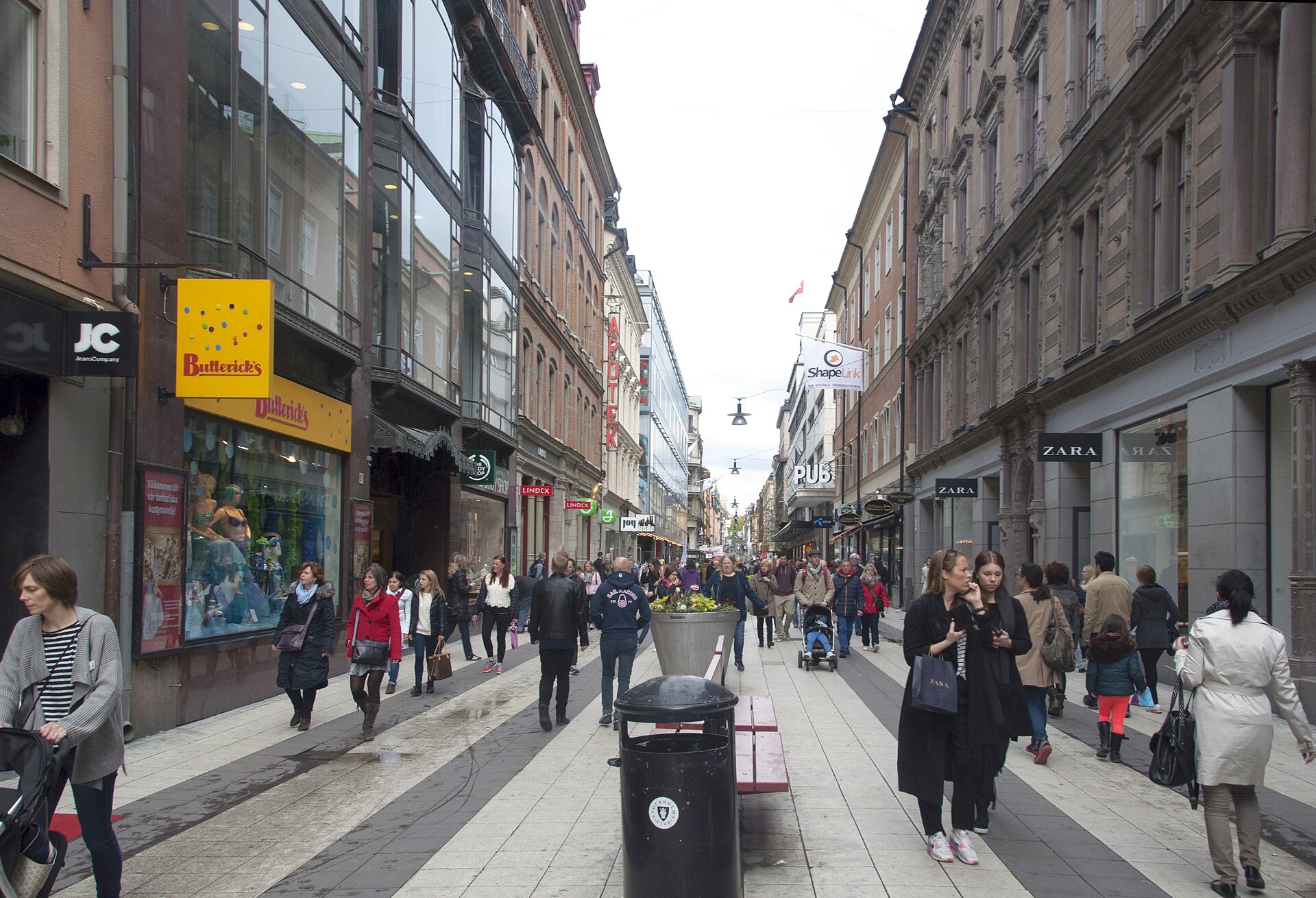

What is on Drottninggatan today?
The street mixes retail with a handful of notable buildings and cultural sites:
- A concentration of chain and independent shops, from clothing retailers to bookshops, running the length of the pedestrian section.
- Adolf Fredriks kyrka, an 18th-century church just off the street, where composer Johan Helmich Roman and philosopher René Descartes (whose remains were briefly interred there before later removal) have historical associations.
- The building known as Blå tornet (“the Blue Tower”) at the street’s northern end, the former home of playwright August Strindberg, now preserved as a small house museum dedicated to his life and work.
- Close proximity to Sergels Torg, the sunken square and cultural hub that marks where Drottninggatan crosses the city’s main east-west shopping street, Klarabergsgatan.
At its southern end, the street opens toward Tegelbacken and the water, within walking distance of Kungsträdgården, the royal garden turned public square, and across the water from Gamla Stan, Stockholm’s medieval old town.
What happened on Drottninggatan in 2017?
On 7 April 2017, a hijacked truck was driven along the pedestrian section of Drottninggatan, killing five people and injuring more than a dozen others. Swedish courts convicted the perpetrator of terrorist offences the following year. The attack led to temporary changes in the street’s traffic barriers and prompted a wider public debate in Sweden about pedestrian-zone security, covered extensively at the time by Swedish national broadcaster SVT and other domestic media. The street reopened to pedestrians within days and has continued to function as one of the city’s principal shopping streets since.
How does Drottninggatan connect to the rest of the city?
Drottninggatan sits within easy walking distance of T-Centralen, Stockholm’s central transport hub, where the metro’s three lines and regional and commuter rail services converge. Its southern end near Tegelbacken also connects to bus routes running along the surrounding streets. Because the street itself is pedestrianized, it works better as a walking route between destinations than as a through-route for anyone relying on buses or trams — for a fuller picture of how the metro, bus and commuter networks fit together, see the guide to getting around Stockholm.
Its position also makes it a useful reference point for understanding how central Stockholm’s districts sit next to one another: Norrmalm’s shopping streets to the east and west, Gamla Stan across the water to the south, and the government and cultural buildings clustered near Tegelbacken. A broader survey of how these areas relate is covered in the guide to Stockholm’s neighbourhoods.
Is Drottninggatan worth knowing about for a longer stay?
For residents rather than one-time visitors, Drottninggatan functions less as a destination and more as infrastructure — a fixed, walkable route through the middle of the city that many people cross daily without treating it as a place to linger. Its retail character shifts gradually: busier and more tourist-oriented near Sergels Torg, quieter and more residential toward Norrtull, with the shift becoming noticeable to anyone who walks the full length rather than just the central shopping block.
The street’s car-free status also means it absorbs a disproportionate share of foot traffic during Stockholm’s main shopping periods, including the run-up to Christmas, when the city’s retail calendar and lighting displays concentrate activity along exactly this kind of pedestrian corridor. As with any seasonal pattern in the city, specific dates and hours for shops and any temporary markets should be confirmed directly with retailers or the City of Stockholm rather than assumed from year to year.
For context on how this fits into the wider pattern of central Stockholm’s public buildings and squares, see the guides to Stockholm’s landmarks and sights and the city’s museums and galleries, several of which — including the Strindberg connection at the street’s northern end — sit within a short walk of Drottninggatan itself.
Access Stockholm is an independent guide written from published, checkable sources. We have not visited the places described here and we do not publish personal recommendations or invented ‘local favourites’ — where something is singled out as notable, we say who says so. Opening times, fares, closures and prices change at short notice, so treat everything here as a starting point and confirm with the museum, operator or venue directly before building a day around it. We give no advice on visas, insurance, health or safety; use your own government’s official guidance for those.
Featured image: Photo by PineappleDolly, source, CC BY-SA 4.0
